


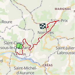
Le Cheylard - Les Nonières (par Saint Prix)

frizou83
User

Length
10.8 km

Max alt
731 m

Uphill gradient
442 m
Km-Effort
15.9 km

Min alt
447 m

Downhill gradient
218 m
Boucle
No
Creation date :
2017-05-06 00:00:00.0
Updated on :
2017-05-06 00:00:00.0
3h36
Difficulty : Easy

FREE GPS app for hiking
 SityTrail
IGN / Geographical institutes
SityTrail Plus
The world is yours!
About
Trail Walking of 10.8 km to be discovered at Auvergne-Rhône-Alpes, Ardèche, Le Cheylard. This trail is proposed by frizou83.
Description
Par la Dolce Via et Saint-Prix
Positioning
Country:
France
Region :
Auvergne-Rhône-Alpes
Department/Province :
Ardèche
Municipality :
Le Cheylard
Location:
Unknown
Start:(Dec)
Start:(UTM)
614441 ; 4974673 (31T) N.
Comments